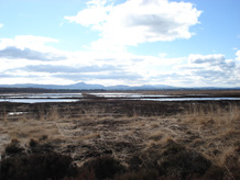
A typical peatland environment. Photo by Dr Karen Anderson, University of Exeter.
Exeter geographer reveals peatland surface patterns
A team of UK scientists led by Dr Karen Anderson of the University of Exeter have developed a new technique for monitoring the condition of peatlands.
The team has used a combination of images captured from Earth and Space to measure spatial patterning in peatland surfaces as an indicator of their condition.
This new method could help monitor the damage that is being done to peatlands through human activity. Such disruption is contributing to global warming, as peatlands can release the carbon they absorb and store if they are damaged by drainage or peat extraction processes.
The research paper, published in the Journal of Environmental Quality, reports that airborne laser scanning instruments are capable of measuring fine-scale peatland structures such as hummocks and hollows which measure less than 4 m in size, typically.
Lowland rain-fed peatlands are recognised as being a globally important environmental resource because they absorb and store carbon. Their unique plant communities and their inherent wetness controls their ability to act as carbon stores, but when human disturbance disrupts their surface structure, greenhouse gases are released instead. Many peatlands across the world are affected by drainage, peat removal and ecological disturbance so scientists have been working to develop a robust spatial method for monitoring peatland condition. Remote sensing techniques (where images from satellites in space are analysed) provide a likely route for this.
Dr Karen Anderson of the University of Exeter’s School of Geography on the Cornwall Campus led the study, which also involved Dr Jon Bennie of the School of Biosciences. Dr Anderson stated: “This work is the first to demonstrate that peatland structures, which are linked to hydrological status and condition, can be measured using remote sensing techniques. Our approach enabled us to draw out the differences in surface pattern across the peatland and resulted in an improved mapping product which is useful for scientists, peatland managers, statutory conservation agencies and for policy makers. It is exciting that research in Cornwall is making a major contribution to this important area of study.”
Research is ongoing at the University of Exeter to investigate broader application of the method to other peatland sites, including an assessment of spaceborne imaging capabilities for global peatland monitoring. The ongoing work will also look at other types of peatlands – including upland peats, which show similar spatial patterning.
This work was funded through a UK Natural Environment Research Council research grant to Karen Anderson (2008) and involved scientists from the University of Exeter, University of Southampton, University of East London, and Natural England.
The £100 million Tremough Campus is a Combined Universities in Cornwall initiative of which the University of Exeter and Falmouth University are two of the founding partners. It is funded mainly by the European Union (Objective One), the South West Regional Development Agency, and the Higher Education Funding Council for England, with support from Cornwall County Council. Set in 70 acres of countryside, but close to the waterside towns of Penryn and Falmouth, the campus offers a lively student community. The University of Exeter now offers degrees in Biology, Modern Celtic and Cornish Studies, English, Geology, Geography, History, Law, Mining Engineering, Politics and Renewable Energy on its Tremough Campus, which has expanded rapidly as part of the Combined Universities in Cornwall initiative.
Date: 1 February 2010